Monday, August 27, 2018

Iceland, Greenland and the Arctic (2)

Iceland, Greenland and the Arctic
(cont'd)
Chapter 2 Arctic Canada
Pond Inlet
Pond Inlet is a small Inuit Community at the northern edge of Baffin Bay.  Looking at the town from the water, it appears as a small, bleak outpost in the Arctic.  On land, it’s the same—bleak.  But the views of the mountains, water and glaciers surrounding the area are beautiful.  We explored the town and found its inhabitants to be friendly and welcoming.  They even put on a show of local customs and culture at their community center.  Seal hunting is an important venture here, and it was not unusual to find seal hides drying on racks.

Pond Inlet, Nunavut


Inuit in native dress

Seal Pelts


View of surrounding glaciers and mountains
In the afternoon, we explored the local bays by kayak.  It was the first time we kayaked with icebergs.  Just getting into all of the gear was an exhausting experience.  We dressed in 3 underlayers followed by a dry suit, splash skirt and booties.  To say we felt like the ‘Michelin Man’ would be an understatement.  But once in the kayak, we had a relaxing and rewarding experience following the rocky coastline and meandering around icebergs.
Fecham Bay and Icy Arm
Today’s walk on the beach was somewhat curtailed because there was a polar bear in the local area that we needed to avoid.  We watched (her) from our balcony on the ship, but honestly, there wasn’t much to see, because she mainly slept.  In the afternoon, we sailed through a magnificent fjord where we saw more polar bears, including a mom and cub.  There were also many orcas.  One pod numbered about 9, and they had made a fresh kill of a narwhal.  The thing I most want to see on this trip is a narwhal, but not a dead one being torn apart by orcas!  The orcas stayed close to the ship all afternoon and appeared to escort us out of the fjord later on.  As a side note: we have not seen a night sky since we left home.  The land of the midnight sun is living up its name, even though it’s past the time of the summer solstice.


Icy Arm fjord


Icy Arm Glacier


Orca


Polar bear mom and cub
Bylot Island
Bylot island is part of Sirmilik National Park.  There is nowhere to land a boat, so our activity was a refreshingly cold zodiac ride adjacent to the towering cliffs to view the geology and bird colonies from the water.  There were hundreds, no thousands of guillemots and kittiwakes nesting on the cliffs as well as some glaucous gulls.  It was a fantastic morning of bird viewing and unusual scenery.


Bird Colony
  
Glaucous Gull


Glaucous Gull Chick

Guillemots


Devon Island

We awakened to a glorious blue sky today.  Our first exploration was of Dundas Harbour, a Canadian Mounted Police outpost that was used intermittently from the 1920’s to the 1950’s to control foreign whaling and other commercial activity in this region.  It was a lonely, barren place situated on the tundra and punctuated by icebergs in the harbor.  The few wooden buildings there were in ruins.  Artifacts were abundant--from rusted cans, empty liquor bottles, bones of animals that live in the area and other detritus.  There was also a cemetery, one of the most northerly in the world.  It seems that two of the men assigned here were ‘accidentally’ killed from bullets to the head from their own guns.  The irony seems to be that if they were so depressed to kill themselves, by doing so they remained on this island forever.


Former Royal Canadian Mounted Police Outpost
(Dundas Harbor, Devon Island)

Abandoned Living Quarters

Beached Iceberg
The captain made an announcement at our briefing on the previous night indicating that the ice report was going to prevent us from further entering Lancaster Sound.  It might be possible to get in, but the way the ice was moving might prevent us from getting out.  Since none of us wanted to get stranded as the early explorers had, we understood and agreed with his plans to visit other areas that were more navigable.  So, on this glorious sunny, mild afternoon we sailed into a fjord which at the end presented us with its prize--stunning views of two tidewater glaciers.  As the afternoon progressed, we lingered to view magnificent reflections from the sun shining on the mountains and glaciers.


Bearded Seal
Philpots Island
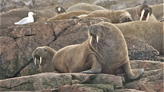
As we arrived at this small island off the coast of Devon Island, the fog played tag with us.  One moment we were marveling at a sunny, blue sky with a remarkable view of an ice sheet on the island and accompanying bergs in the water.  Then in a snap, visibility was reduced to zero and we were seeing only fifty shades of gray.  Nevertheless, we donned our gear—3 layers of everything, to take a zodiac ride around the area.  The first thing we saw was an item on my wish list, something I’d never seen in the wild before, a walrus.  But not just one, there was a whole group of them resting on the rocks and some swimming in the water.  Such a treat!!  Now, if I can only get a better view of narwhals, especially males with their large tusks, my wishes will be fulfilled.  Our ride continued with sightings of a few birds and many icebergs.  And now a word about the icebergs.  Each is totally unique in structure, color and texture.  As we gaze upon them, it’s easy to think that nature has carved each one into a piece of art.  Some look like animals, others look like architectural works and so on.  The colors range from white, to transparent, to many shades of beautiful blues and aquas.  And the texture can be smooth, striated or look like frosted glass or bubbly glass. 


Walruses


In the evening, the Captain gave us an update with the ice map, indicating that we would need to make yet another diversion.  So, Ellesmere Island is now off the itinerary, and we will be sailing back to Greenland for the rest of our cruise.

FOR CHAPTER 1 CLICK HERE:  CHAPTER 1

Thursday, August 23, 2018

Iceland, Greenland and the Arctic

Iceland, Greenland and the Arctic
 
Chapter 1
 
This summer we decided to explore the North Atlantic Arctic.  Our adventure started in Iceland where we took a charter flight to Kangerlussuaq, Greenland and boarded our expedition ship, the Silversea Silver Cloud.
Charter Flight to Kangerslussuaq

Silver Cloud
 
On board the Silver Cloud, we visited small villages along the west coast of Greenland as we sailed north to the Arctic Circle and beyond.
 
Map Showing Arctic Circle
 The Arctic Circle is the most northerly of the five major circles of latitude as shown on maps of Earth. It marks the northernmost point at which the noon sun is just visible on the December solstice and the southernmost point at which the midnight sun is just visible on the June solstice. The region north of this circle is known as the Arctic, and the zone just to the south is called the Northern Temperate Zone. (Wikipedia)
 
SISSIMIUT
The first town on our itinerary was Sissimiut, Greenland, a picturesque town located on the central west coast.  Immediately, we were struck by the very unique scene in front of us.
Itinerary

Houses were brightly painted in reds, blues, yellows and greens, the primary and secondary colors of a small Crayola box.  They were perched on rocky cliffs, as the land was all rock and mountains.  There are no trees here, just grasses, moss and wild flowers.


Greenland is part of Denmark; the population is a combination of Danes and Inuit people.  The Danes first settled the area in the 1720’s, whereas the Inuit are descendants of arrivals from about 1,000 years ago.  A walking tour of the area revealed a larger than expected town with shops, an airport, hospital, and both single-family and multiple housing units.  There are also sizeable schools, since there are about 5,500 people living here.  All goods are brought in by sea (or air), since the roads end with the town.  Beyond the town, there are mountains and wilderness.
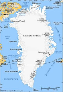
Greenland
The last stop on our walking tour on the outskirts of town was a visit with Greenland sled dogs.  There were many of them, and they were spread out on a rocky hillside.  As we approached the area, we were struck by their large size.  They had beautiful coats and started howling as we neared.  It was bothersome that they were all chained, but we reminded ourselves that our views on the subject are not always applicable in all situations.  Our understanding is that this is the norm for sled dogs.
 
After visiting Sissimiut, we reboarded the ship and started plying our way north toward the Arctic Circle.  By morning, small icebergs started appearing in the water.  As we continued north, the bergs got a bit bigger.  We haven’t seen too much wildlife yet, mostly seabirds and a pod of pilot whales, but we’ll keep looking.


UUMMANNAQ
 
About 300 miles north of the Arctic circle, we found ourselves in Uummannaq, a small town that is a hub for halibut fishing.  Again, there are brightly colored houses perched on the rocky cliffs.  We heard that the color of your house depends on the year it needs painting.  Each year, only one color of paint is delivered, and if it happens to be the time you need to paint your house, then that’s the color you will have.  This town is quite active, with many of its inhabitants outside on this warm, sunny summer day.  The harbor is busy with fishing boats and other watercraft skirting icebergs as they go about their business.  As we walked through town, we occasionally heard a loud cracking sound, followed by the calving of one of the icebergs.


Town of Ummannaq
Our Ship, Silver Cloud

Large Iceberg in the Harbor


Northern Fulmars

As we gaze at the surrounding mountains, one thing is very clear.  There are numerous glaciers, but they have retreated so much that only a small area near the top of the mountain is still covered in snow and ice.  Clearly visible is also the moraine that has been left as the glaciers receded.  The town is named for the heart-shaped mountain that is its backdrop.
After a day at sea, our next chapter begins at Pond Inlet, Nunavut in Baffin Bay.
 
  
(Due to the weak internet signal we have in the arctic, quality and timing may be limited.)